Where in the world are we?

Where in the World are We?

28 January 2011

The Colombia Collection

As we head off to our next destination, we wanted to leave our readers with just some final shots from our time in Colombia. We had a wonderful time while in Colombia and were also fortunate enough to reconnect with some of our friends with whom we served in Peace Corps Belize. It sure seems like a small world sometimes. Colombia is a beautiful and vibrant country filled with wonderful people. We definitely plan to make a return trip to continue our explorations of this amazing country. Enjoy the photos!

Balconies across Cartagena


Some of the many fancy door knockers on the old colonial homes


Beautiful streets around every corner!


Everything is for sale...Panama hats, fruit, fish, bread, meat (on the far right, second from the top), sweets in jars, jewelry, paintings, arepas (AKA cheese-filled goodness)


RPCVs from Belize (Olivia and Matt)


Nicole, one of our fellow RPCVs who served in Belize City with us


Some city wildlife...these guys were huge!!!


Resident Bird at La Casa de Rafael Nunez, one of Colombia's famous fathers


This sure beats a Nor'easter!!!

Where are we off to next, you may ask? Well, here's a hint for you!
~the stonework in this city is tapered upwards and every wall has a perfect line of inclination toward the center (from bottom to top); in fact, one building is said to be unequalled in the world

We'll be sure to take pictures of these buildings and all the other sites we soon will visit.

Paz y Amor!

26 January 2011

Castillo San Felipe de Barajas

Last Thursday (20 Jan) we visited the historic Spanish Fortress Castillo San Felipe de Barajas.The Castle stands guard high on a hillside overlooking the city and harbor. Many believe this impressive Spanish fort to be the greatest and strongest fortress ever built by the Spaniards in their colonies.


A Bit of Cartagena History…

Cartagena was founded in 1533 by Spanish Conquistador Explorers led by Pedro de Heredia. Within months of their landing, they decimated and enslaved the indigenous native Calamari tribe of Indians and became the masters of this very important port. It became the treasure city of the Spanish and served as the primary transfer/shipment port for precious gems and minerals destined for the coffers of King Ferdinand. When many Spanish Galleons, laden with riches from the new world, were attacked and seized by Pirates and English war ships, King Ferdinand ordered the city to be fortified to protect Spain's treasures. The fortress that remains in existence today, Castillo San Felipe, took nearly 200 years and 245 tons of gold to build.

Cartagena suffered invasions and sackings in 1544, 1560 and in 1586 (by Sir Francis Drake). In 1741, the English Commander, Edward Vernon, with 186 ships and 25,000 men laid a three month siege to the city. He was so certain that Cartagena would be his that he had a medal struck commemorating his expected victory. However, the Spaniards, outnumbered seven to one, held firm behind their walls and fortresses. The smaller cannons on the English ships were able to bombard the outer walls of the fortress but could not reach the distances and heights of Castillo San Felipe. The castle's cannons on the other hand, made prime targets of the English ships whenever they ventured within range. Vernon lost over 70 ships and 10,000 men in his ill-fated attempt to take the city. Those of you who have been following our blogs may remember that Vernon also took control of Fort San Lorenzo in Panamá.

As we journeyed through the different areas of the huge fortress we climbed walled areas, wound our way through elaborate mazes of tunnels beneath the surface, and took in some incredible views of the surrounding coastline. It was definitely one of the highlights of our visit to Cartagena and certainly one of the most impressive forts we have visited thus far on our travels.

Paz y Amor!

22 January 2011

Primeras Vistas: Cartagena de Indias, Colombia


Our journey has brought us to South America, the fourth continent each of us has visited! We included Colombia on our itinerary because we have made some wonderful friends from here and were intrigued by the country’s allure. Since it is quite a large place, we used the World Heritage List as our guide and landed here in Cartagena de Indias (or more commonly called simply Cartagena).

Due to some travel logistic challenges (meaning a way too long, costly, and potentially unsafe bus ride through the Andes) we are unable to visit our good friend and Spanish tutor, Diego in his home of Cúcuta, but we have some other friends in the area who we hope to see before we move along. Needless to say, we have a bit of extra time to further explore and enjoy the city and our walks along the beautiful colonial streets.

Cartagena is a Spanish colonial city with several fortresses and churches. The old city itself is surrounded by a protective wall to deter invaders coming by way of the sea since it lies along the beautiful Mar Caribe.


As we tour the old fortresses, churches, museums, and streets of Cartagena, you can be sure we will take a lot of photos to share in our upcoming posts. For now, simply enjoy some first looks at the beautiful city in which we are so lucky to spend time exploring and enjoying.

Paz y Amor!

16 January 2011

Fuerte San Lorenzo and The Gatun Locks


When we returned to the city we decided to take advantage of another nice day and head out to the Colón province of Panamá to visit the Gatún Locks at the canal, as well as to make our way out to the famous Fuerte San Lorenzo. Our trip to the locks was an interesting challenge – having no road signs and maps that gloss over the area, we had nothing but instinct and the piecemeal directions by various locals to go by. After over an hour of turning around and stopping for more directions and repeated assurances that we would see a sign, we ended up at an RCI resort where we got a map made on MS Word that was severely lacking in clarity, but at least gave some idea of where to go and finally, we found our way!

The Gatún Locks are located on Colón’s Atlantic coast and are the first set of locks when entering Panamá. They are made up of three chambers, each 100 feet wide and 1000 feet long. Vessels passing these locks are raised 87 feet above sea level to enter the Gatún Lake, an artificial lake that actually also serves as a water resource for the Canal operations. Once the ship finishes its transit throughout the reservoir, it will meet the next two locks and gradually lower the vessel to sea level as it exits into the Pacific Ocean. This was the second set of locks that we visited and the cool thing about Gatún is that cars and other vehicles are able to pass across the canal before and after ships make their passages. On our way back through, we actually were fortunate enough to get a great shot of a ship coming through the canal as it waited for cars to pass.


On a side note, as we were looking for the road to Fuerte San Lorenzo we bumped into a construction site down the road from the Locks and came upon a really nice guy who was actually from Detroit. It was funny as Anthony asked him where something was and they started to converse back and forth in Spanish before he asked us if we spoke English. As it turns out, he was working on a crew out by the locks actually excavating and building a new site that will become a third set of locks. As we spoke with him, he pointed all around and showed us the different areas that were being developed, saying “Take a picture of all of this, because next time you come to Panamá, it will all be turned into the new Locks, enabling a third ship to transit.”Gatún was just really cool and never ceased to amaze us with the incredible examples of engineering at its best.


Once we passed over the canal we headed toward Fort San Lorenzo. En route we passed Fort Sherman, an old United States military base, which as it is now, has become the site for Panamá’s naval base. The old base was pretty interesting to drive through and much of it was completely abandoned and in a state of disrepair. It looked as if people just packed their things and left, which is apparently what happened when the U.S. abandoned the area in 1999.


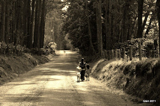
As we entered the road to the Fort Lorenzo site, we were greeted by an older Panamanian gentleman who after a bit of conversing about where we were from and such, ended up allowing us to enter the site for $5 instead of the requisite $10. We began our trek down the dreaded road to the Fort (which by the way, was nowhere near as bad as many of the roads in and around Belize that we have experienced). We reached the Fort after a short 10-15 minute ride through some pretty thick jungle that opened up at the end to a beautiful vista of the Caribbean Sea with Fuerte San Lorenzo high on the nearby hills. When we arrived we also had the entire site to ourselves, which incidentally made for some great picture-taking opportunities.


The fort was declared a UNESCO World Heritage Site and remains one of the oldest Spanish fortresses in the Americas. Originally built in 1597 when King Phillip of Spain commissioned his men to create a fortress that would strategically protect the mainland coasts from the repeated attacks of pirate Francis Drake (Drake had been attacking the surrounding areas of Nombre de Dios and Camino Real).

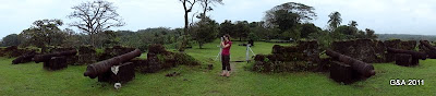
During these times Panamá served as a major transit point for all of the treasures coming from nearby Peru. In 1671 Admiral Henry Morgan sent over 400 men under the command of Pirate Joseph Bradley to take over the fortress in an uncertain and challenging expedition. At first, the Spanish forced Morgan’s men to initially retreat, however, before leaving and losing all of their momentum, one of the Englishmen was able to set fire to the fort, helping them to not only advance and kill many of the Spaniards, but to also completely take over the fort (sort of like the taking of Helm’s Deep for those Tolkien fans out there). Before leaving the fort, Captain Morgan actually destroyed most of it. 80 years later in 1677, the Spanish rebuilt the fort, this time stocking it with additional cannons, batteries, and barracks. Although rebuilt and further fortified, the Spanish once again fell victim to the English, this time in the form of Admiral Edward Vernon in the year 1740 (Vernon incidentally is the same person for which Mount Vernon is named). During Vernon’s attack and bombardment, he captured and demolished Fuerte San Lorenzo soon after taking over the nearby Portobelo forts. The fort was bombarded over two days with 200+ lb. mortars that were filled with gunpowder and inflicted heavy damage, causing major destruction. After Vernon and his 200-man army took over the fort, it was once again destroyed. The ruins that remain standing today are the remains of the last reconstruction by the Spaniards in the year 1750.

What's Next??
Our time in Panama has come to its conclusion and now we will journey on. We're traveling to one of the first Spanish cities founded in Latin America and remained under Spanish rule for over 275 years. The city today remains surrounded by a wall over one mile in length.

Paz y Amor!

15 January 2011

"The Land of the Eternal Rainbow"

...or, we might say “quick, take a picture the sun is out!”

We have spent the past four days in Boquete in the Chiriquí Province of Panamá. We are near Panamá’s highest point – Volcan Barú (3474 km; 14,500 ft) and in a pocket that has very cool weather. It’s a small, quaint town with a simple town center including a central park and a few shops and various activity centers.


We traveled west to experience a different climate and to see another side of Panamá. The town certainly offers a lot in adventure tourism, but our purpose was to relax in the mountains and take in the scenery and some of the sights of the area.


After a seven-hour drive along the Pan-American Highway on Sunday, we reached the Mamallena Boquete and settled into our mountain “home.” We expected the drive to include some beautiful vistas such as we’ve seen in Costa Rica and Belize, but actually involved passing through several towns and then quite a long stretch of open land with some very brown dry grass and mountains far in the distance. At this point, the highway also reduced to a simple two-lane, two-direction long stretch (for several hours!). It was still a good way to get a glimpse of different areas in Panamá.

Highlights of our time in Boquete:

Mi Jardín es Su Jardín

This is a beautiful garden on the private residence of a man who believes in sharing the beauty of Boquete at no cost. Anthony read an article about the owner in a local paper and he is 99 years old and still comes into town daily for coffee and mingling.

The gardens cannot be described adequately in words, so here is what we saw (also, the pictures of flowers throughout the post are from the gardens):

The weather is best described as ephemeral (at least for these past 4 days!). One moment it is cold and windy, the next hot and sunny, and yet the next rainy. At the garden we both ended up sunburnt because the day started grey and cold and we expected to wear long sleeves all day. We learned that lesson quickly!

The walk to the gardens took us north through the town center and past the famous Café Ruiz, described as having the best coffee in Panamá. Not being coffee drinkers, we wonder if we are missing out, but then the smell of the coffee quickly reminds us we are not J

Cascada San Ramón and Vistas of Volcan Barú

Tuesday morning we woke early to get out before cloud cover set in over the mountains so we could take a hike to Cascada Escondido near the start of El Sendero de Los Quetzales (this hiking trail is closed due to the heavy rains that have been falling throughout the country flooding various areas and causing all sorts of other travel problems throughout Panamá, as well as contaminating the water supply explaining why there is such a shortage of bottled water everywhere!). We drove a loop outside of town and came to the Cascada (waterfall) San Ramón and snapped some photos. Despite our early departure, the rain was already upon us, but we thought it may clear up as it had on Monday. We reached the entry to the sendero for the other cascada and it was still raining. Neither of us felt compelled to walk for an hour and a half in the rain, so we decided to continue the loop and drive out to the start of the sendero Barú (trail to hike the volcano) to see the views - to hike to the top of the volcano would require a good 6-7 hours and far more warm clothing than we have.

The rain continued off and on, so we took some photos of what we could see of the volcano and then returned to town for the afternoon, thinking if it cleared we’d go back for the hike. On the road to the volcano we encountered strawberry fields and saw many local people along the road, women in their traditional dress giving us a glimpse of local life in Panamá’s montañas.

Speaking of strawberries, they are abundant up here! They sell overflowing cups of them for $1 and have shops selling chocolate-covered strawberries and various strawberry treats. The famous is the strawberry batida – a local milkshake. It’s not like a milkshake made with ice cream, though, and seems a bit more of a liquid-y smoothie.

The rain and wind never did stop on Tuesday, so we just relaxed with our books and other travelers for the afternoon.

The Petroglyphs (Las Piedras Pinturas) in Caldera

After a fitful night of powerful wind and rain, we awoke to another cloudy day so we headed out of town to Caldera. 25 km away is a town that boasts hot springs and petroglyphs. We took the walk out to see las piedras pinturas (the painted rocks) that are on a local man’s property in the village of Caldera just a few kilometers before the hot springs. Just a few kilometers outside of Boquete Town and we were once again enveloped by the hot sun and blue skies!

The walk took us through a large pasture where we had to dodge giant cow patties and search for the orange sign that falls along the path toward the rocks. The views of the mountains and palm trees and big full trees are gorgeous and we also stumbled upon some sections of volcanic rock that were not the ones we were looking for. We managed to navigate with the hand-drawn map provided at the hostal and discovered the carvings. They have been outlined by someone with chalk (at least seemed to be since it is doubtful ancient Indian civilizations colored them in!). It’s interesting that only one rock has the carvings in this area. However, there have been several similar carvings discovered in other parts of the country and archaeologists believe they tell stories. We haven’t found anything directly describing these carvings, but they were interesting to see.

Anthony finished his book and luckily discovered a used bookstore in a community not far from David, so we visited The Bookmark to find him a replacement. It was great to be surrounded by so many good books – we spent over an hour browsing and fortunately Anthony found something he liked, and we hope will get us to the next place with a book exchange or shop! We’ve enjoyed the used and exchange book shops in all our travels through Central America and always find something new and interesting along the way!

Feria de Las Flores y del Cafe

Thursday January 13, 2011 brought the opening day of Boquete’s annual fair of flowers and coffee. It reminded us of expos in Belize with rooms for vendors to sell anything from jewelry to electronic equipment (the one thing lacking was the cell phone deals and credit sales!). The fairgrounds are landscaped with the beautiful, vibrant flowers that grow so well in this soil and had several vendors offering a variety of foods and treats. There were some agriculture exhibits and a few places showing real estate availability and growth. At night, the party started around 7:30pm with a party in the park and the requisite ginormous speakers, which we are used to from our days in Belize (unfortunately, said speakers are right across from our room!!).

Boquete truly is a land of the eternal rainbow (as described by the title of a book about the area) as we have seen one every day. They fill the sky arching over the town and the Río Caldera that runs to the east. It has been a restful place to visit (well except for the windy nights and the strange 15 minutes of loud music blaring from nearby speakers at midnight Thursday morning!) and we are glad we got to see another side of Panamá.

Where to Next??

We’ve returned to Panamá City, but will visit another major location before leaving the country. It’s the UNESCO site where Henry Morgan gained access to Panamá.

We enjoyed the responses to our previous posts. We have to credit both Mica & John and Chris, since he added that clarification point and we feel generous!

To everyone, keep those guesses coming. We are going to be traveling to some pretty cool markets and will find quite a fun prize!

Paz y Amor!

Just for giggles...
"This hamburger is amazing. He must have gone to Jared!"