Where in the world are we?

Where in the World are We?

Showing posts with label Peru. Show all posts

16 February 2011

Cuzco, La Ciudad Imperial


The World Heritage City of Cuzco, Peru served as our home base for our adventures in the country. All together we spent 7 full days and a couple additional evenings in between our visits to other places.

Cuzco has a rich history as the center of the Inca Empire and currently as a destination for those traveling through the Sacred Valley and onto Machu Picchu. We enjoyed our days in the city and always found interesting sites to see and steep cobblestone streets to explore.


The Plaza de Armas is a beautiful central point for the city and is surrounded by two large churches (which sit atop former Inca sites) and has several restaurants and cafes and a lovely park in which to relax, people watch, and practice Spanish. We spent a lot of time walking through the Plaza de Armas on our way to other streets and for browsing artisan markets and café menus.


During our time in Cusco, we visited the museums on the Boleto Turistico General (which we mentioned earlier) and also toured the streets admiring the remaining Inca stonework on the buildings and the various markets and ships throughout. We even enjoyed an evening show of local and Andean dances and music.

just one of the many interesting pieces of art we saw on this trip


We also were pretty pleased to find two completely vegetarian restaurants and several other places with great vegetarian options, as well as some new favorite treats (among them are the small chocolate truffles at Chocolate and Inca Corn - addictive gigantic pieces of maize, we like the picante flavor, of course! - and Camote [sweet potato] chips and a brilliant ice cream bar that is half ice cream sandwich/half chocolate-covered ice cream bar). This has been the first place to provide a wealth of dishes for we vegetarians and to have affordable options. We were able to try a veganized version of a Peruvian dish – Lomo Saltado, which is made with sautéed meat and vegetables served over french fries with a side of rice. Ours was made with a really great soy meat. ginnie is eager to learn how to recreate these soy meats we have tried and add more new dishes to our recipe book.

We underestimated just how cold it can be at 11,500 feet and have added some nice alpaca socks, gloves, leg warmers, and a sweater to ginnie’s wardrobe in our time here as well. Anthony keeps passing up the hats, but often wishes he had one when the cold really hits. This has been one place where the temperature change from minute to minute can be drastic! When the sun is shining, we are comfortable in light clothes and t-shirts, but as soon as it is covered, we need to layer up again; don’t even get us started on the rain! We have been lucky with the weather overall, but when it does rain, it can be pretty chilly J

Our photos provide a glimpse into the city and the architecture. We visited an important Inca site –Qoricancha – which is now a Dominican Friar’s residence and school. It’s disappointing and aggravating to see how much the Spanish Conquistadors destroyed and how they took over to impart their religion on the people. The Qoricancha site is a mix of both Inca stonework and Spanish and Catholic stonework and art. The contrast is obvious since the Inca work was done with such precision. Throughout the city you can see the combined remains of Inca buildings with current structures.


As our time in Peru comes to a close, we leave you with some views of Cuzco and a few hints as to the next country on our South America tour:

~we’ll be spending more time in the Andes and enjoying restful days by the mountains, lakes, and beautiful countryside

~our first stops include the capital city and a visit to the town where the Saturday market is said to be the biggest and best in South America

Paz y Amor!

15 February 2011

Festivals, Markets, and Pre-Colombian Tombs


During our time in the southern city of Puno, Peru we had the opportunity to take in many of the surrounding sites. On one particular day we walked around the city and visited the local markets, observing some of the celebrations that were taking place in honor of the Feria de la Virgin de la Candelaria, an annual festival that lasts for eighteen days and for which people travel from all over the country to participate in parades, processions, and religious services in honor of the Virgin Mary. We were fortunate to observe a few of these and were struck by both the beauty and complexity of many of the costumes, as well as the strangeness and odd representations of what we’re not quite sure, e.g. children wearing Native American outfits and holding guns and a young participant wearing a gorilla costume. Either way, we really enjoyed the festive atmosphere and traditional music played throughout.


On a walk to the shore of Lake Titicaca we found ourselves in the middle of Puno’s weekly market – a hub of activity! The items for sale ranged from kitchenware to toiletries to clothes to heaps of candy to fresh produce. There were potatoes of all varieties, and many dried peppers, spices, grains and meats. One in particular was a dried and skinned type of fowl that we did not get a picture of, but have had the image imprinted since. It was fun to walk through the market, if a bit overwhelming; we thought if we lived in Puno we would have no idea how to select where to buy what we needed for the week! We’re sharing a few of our favorite shots from the market.

oveja - sheep


The afternoon before we left for Cusco, we ventured out to the famous Sillustani ruins just outside of Puno. The ruins are very different from those that we have previously visited. At the site are the Chullpas (pre-Columbian funeral towers) of Sillustani, beautifully set on a peninsula in Lake Umayo.The Chullpas were built by three different pre-Colombian cultures, the Pukara, the Aymara-speaking Collas - a tribe that dominated the Titicaca region before the Incas after the Pukara was split by differing allegiances in Bolivia and Peru. At the site are three different style Chullpas: the rougher appearance of the natural unsmoothed stone of the Pukara, the curved, but smoothed edge stone of the Colla, and the smoothed and neat edged stone of the Inka. Each tower contained the remains of each culture’s nobility accompanied by their riches and even their servants in some instances. It’s kind of a downer to learn that grave robbers have since removed their contents, but fortunately many of the towers are well preserved and were definitely worth the visit. We had a great tour guide who ran the whole three hours in Spanish, thank goodness we’d been prepped with six weeks of intensive language practice. A point to note regarding these ruins is that much of the engineering involved in their construction is more complex than anything the Incas built. “Ancestor worship and kinship were integral parts of Aymara culture, and the chullpas were built to emphasize the connection between life and death.[2] The insides of the tombs were shaped like a woman's uterus, and corpses were mummified in a fetal position to recreate their birth. Some of the tombs also have lizards carved into the stone. Because they could regrow their tails, lizards were considered a symbol of life. The only openings to the buildings face east, where it was believed the Sun was reborn by Mother Earth each day.” (www.aboutperu.com)

The site was really amazing and definitely held some mystery. The lagoon surrounding the site, as well as the island in the center provide mystical stories for locals and give the site it’s magical beliefs.
Paz y Amor!

14 February 2011

Islands of Lake Titicaca


On February 10th we journeyed by bus from Cusco to Puno, Peru in order to venture out on Lake Titicaca, the world's highest navigable lake (and a tentative World Heritage Site). When we arrived on Thursday, we arranged for visits to a couple of the islands out on the lake. In order to reach each of the islands it required an early wakeup call on Friday to the tune of 5am, being that neither of us is a morning person, this was a bit difficult, but fear not…we did it! We were picked up from our hotel and taken to a rather small vessel (did I mention that neither of us is too fond of boats?). The boat held approximately 25 passengers snuggly in a tight cabin area, thankfully there was a deck up top which Anthony utilized quite often in warding off any feelings of seasickness that approached. Before going any further, we should mention that these boats that travel out to the islands are old, shaky, running on rebuilt diesel car engines and top out at 12mph.


The first islands we visited were the floating islands of Uros (approximately 40 minutes off shore).The community is made up of a series of approximately fifty individual islands all interconnected through a series of small reed made sea-going vessels that enable residents to barter and trade with not only one another, but also with people on the mainland in the city of Puno (see pictures below). When we arrived to Uros we were met by the leader of the island who, through a local translator, demonstrated many of the daily routines and practices that make up the lives of the people residing there. Uros are a pre-Incan people who live on these fashioned floating islands in Lake Titicaca. They form three main groups: Uru-Chipayas, Uru-Muratos and the Uru-Iruitos. The last group is still located on the Bolivian side of Lake Titicaca. The Uros use bundles of dried totora reeds to make reed boats (balsas mats). Early schooling is done on several islands, including a traditional school. Older children and university students attend school on the mainland, often in the nearby city of Puno.


The Uros descend from a millennial town that according to legends are "pukinas" who speak Uro or Pukina and that believe they are the owners of the lake and water. Uros used to say that they have black blood because they did not feel the cold. Also they call themselves "Lupihaques" (Sons of the Sun). The purpose of the island settlements was originally defensive, and if a threat arose they could be moved. The largest island retains a watchtower almost entirely constructed of reeds.About 500 years ago the Uros lost their original language when conquered by the Inca Empire.During this time, they had to pay taxes to the Inca and were often made slaves.


The larger islands house about ten families, while smaller ones, only about thirty meters wide, house only two or three. The islets are made of totora reeds, which grow in the lake. The dense roots that the plants develop and interweave form a natural layer called Khili (about one to 7 feet thick) that support the islands. They are anchored with ropes attached to sticks driven into the bottom of the lake. The reeds at the bottoms of the islands rot away fairly quickly, so new reeds are added to the top constantly, about every three months. When walking around the islands they feel a lot like walking in drenched grass or hay; sometimes we even felt as though we’d fall right through to the lake below. As the reeds dry, they break up more and more as they are walked upon. As the reed breaks up and moisture gets to it, it rots, and a new layer has to be added. The residents described the great deal of time and effort necessary by all families to maintain the island on a regular basis…it requires quite a lot of work!

Much of the Uros' diet consists of fish, eggs, and birds such as seagulls, ducks and flamingos.Food is cooked with fires placed on piles of stones for obvious reasons related to fire danger. This was a really cool stop and definitely another of the most anticipated during our trip to Peru. Before heading out to the next island, we took a short ride across the water on one of their crafted reed boats made to look like a two headed dragon. We were sung to by the villagers and then wished a safe journey before returning to our own boat and heading out on the 2.5 hour journey to Taquile Island.

Although only 30 miles away from Uros, it took an extremely long time, although it was an incredibly beautiful day and the lake’s surface was like glass. The inhabitants, known as Taquileños, are southern Quechua speakers. Taquile is an extremely hilly island (we had to hike uphill for about 30 minutes just to reach our first stop!). It is narrow and long and was used as a prison during the Spanish Colony and into the 20th century.

Taquile was part of the Inca Empire and has a number of Inca ruins. The island was one of the last locations in Peru to fall into Spanish hands during the Spanish conquest of Peru. Since the Spanish did not allow traditional dress, the islanders adopted the Spanish peasant clothing and as we traveled around the island these traditional representations of dress were everywhere. One of the more interesting facts about the Taquileños is that they run their society based on community collectivism and on the Inca moral code “ama sua, ama llulla, ama qhilla.” (Quechua for "do not steal, do not lie, do not be lazy"). The island is divided into six sectors for crop rotation purposes and their economy is based mainly on fishing and farming (mainly potato cultivation).


Through our travels in Central and South America we have seen a great number of talented craftsmen and artisans; however, the talent of the Taquileños in this department far surpassed much of what we had seen in other parts. As we learned on our visit, these people are very well known for their fine hand-woven textiles and clothing, and many regard their work as among the highest-quality handicrafts in Peru. Knitting is exclusively performed by males, starting at age eight and women exclusively make yarn and weave. (In 2005, "Taquile and Its Textile Art" were honored by being proclaimed "Masterpieces of the Oral and Intangible Heritage of Humanity" by UNESCO.)All of the men and boys on the island wear hats that are woven to distinguish whether they are married or not. A male with a hat that is completely colored with woven designs and textures is recognized as a married man, while other males wear hats that are half white and half woven in colors. These hats are worn everyday as part of the traditional dress and as a result, make it very easy to determine who in the community is married.


Taquile has a radio station and is equipped with generators, although islanders have elected not to use them and use solar panels instead. One other point of interest, Taquile has the curious distinction of being free of dogs, with many natives actually considering dogs and cats delicacies. We spent a few hours on the island visiting with a family, watching some traditional dances, and listening to typical music played on different string instruments and drums. Before leaving we enjoyed a visit to the town square high atop the island which provided some stunning panoramic views of the surrounding lake. It was definitely a really unique experience and one that we won’t soon forget (although we could have done without the 3 hour return boat ride…thank goodness the sun held out and we were able to enjoy the trip back to Puno).

Paz y Amor!

13 February 2011

Machu Picchu

Ollantaytambo Village to Aguas Calientes

On Saturday we headed out from our hostel to the railway station where we boarded our Peru Rail train for the much anticipated visit to the ruins of Machu Picchu (World Heritage Site and one of the new 7 wonders of the world) deep in the Andes. The train ride was really amazing. We chose to take the Expedition train and were really glad that we did. During the 2 hour ride to Machu Picchu we were able to take in all of the scenery en-route by way of large panoramic windows in our carriage on each side, as well as on the ceiling. During the ride, they also played soothing music from the Andes which really created the perfect environment and put us into quite a peaceful state of mind. (It didn’t hurt that they provided chocolate and pretzels for snacks either). We arrived at around noon to Machu Picchu Town (aka Aguas Calientes) and spent the day preparing for our adventure.

Machu Picchu

We awoke before sunrise, at 5am on Sunday the 6th of February to visit one of the most anticipated stops on our tour of South America – Machu Picchu. At around 2pm the day before, the skies opened up and it rained fairly consistently throughout the evening and night – with a few breaks that gave us some hope for a non-rainy day to follow. Our B&B hotel is right on the Aguas Caliente River, so we often heard the rushing of the river and sometimes confused it at first with rain. We were pretty convinced that we would not see a sunrise (based on the typical weather for Machu Picchu which is often skirted in clouds for the better part of the morning). We also knew there would be no sunrise viewing just based on prior experiences (for those who’ve known us long and followed the blog through some Central America trips you know we do not have luck with clear skies for any sunrise activity!) so we planned to be on a 6am bus to the site. We made it and at 6:10 our bus was on its way up the curvy and harrowing steep slope toward the most impressive archaeological site we have ever seen.

Our first glimpse as the fog lightened for a moment!


llamas enjoy the views, too! :)

Our luck with cloud cover meant we could not actually see the mountains or the ruins as we drove up, or even as we first walked into the site! We did see the buildings that were within our line of sight and not blocked by the deep mountain fog that first appears along the mountainside so we went in to check them out and see if there were any other ruins in the distance. We continued upward and came to another building higher up on the mountain that served as a guard house for the Inca and were excited to see the fog start to break and provide us a glimpse of the main living area of the site – we quickly snapped some photos before it covered back up then spent a few more minutes sheltered by the thatch of the guard house along with several other visitors. The best part of the early arrival was the smaller number of visitors and feeling like we had the site all to ourselves for a couple of hours. We spent some time hiking to the Sun Gate and along some of the smaller trails on the opposite more remote area of the park. The hike to the Sun Gate was long, and not very rewarding (in terms of the vistas) as the fog continued to wreak havoc on our early morning visit.


We returned to the main area of the complex and after some time spent sheltering ourselves in the Inca guard booth, we peaked out and saw that the fog was pushing away and making the site much more visible. Excitement ensued among all the visitors and we all rushed out to take turns taking photos. The fog rolled in again and we returned to our post for a short time before planning to walk the trail to the Inca Bridge (Puente de Inka); yet, after a somewhat long morning of on-and-off-again rain, shivering, and altitude adjustment, we became pretty hungry and opted to return to the entrance for our bags to make peanut butter crackers and pick up a few more of our energy bars and snacks.


vistas throughout the day


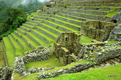
terrazas (reinforce the mountain to support the weight of the structure above and used for agriculture)
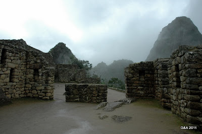

The walk to the Puente de Inka was really incredible following along a steep trail etched out of the mountain with shear drops at up to 1000 feet. Many visitors commented, and we enthusiastically agreed, that they were not winning any awards for safety on this particular trail. There actually were areas where we had to hold onto a nylon rope that was secured to the mountain because the path grew so narrow. We both completed the trek, not sure why neither of us questioned the safety while en-route, but we definitely pondered a bit more on the way back. It is unimaginable to consider how the Inca even built this bridge right along the mountain (let alone the entire site!). ginnie discovered a pretty strong fear of heights at this moment, but made it to the bridge and back. We made our way back carefully through the very narrow path perched over 800 feet up and once on more secure footing were ready to explore the buildings of the site.


Puente de Inka - look at that steep drop!


one of our first clear views!


When we returned to the site, it was still really windy and we needed a pit stop at the guard house to dry off the camera and rest. While in there, ginnie noticed the rain was moving sideways – parallel to the ground – because of the wind. We kept hoping for just a little sun. When we got into the buildings, we got our wish and the rain stopped and we had about 3-4 hours of calm weather with enough sunshine to keep our views clear. It was perfect for looking mesmerized at the intricate stonework indicative of the Inca. The granite looks as if it is put together like a perfect puzzle – it’s incredible. We both were fascinated with the enormous presence of the mountains surrounding the site and the tall structures. We also visited the astronomical observatory where the Temple of the Sun sits right in the center of 4 mountains and has its own compass pointing to the four cardinal directions, as well as each of the four sacred mountains observed by the Inca.


close-ups of the structures and stonework

We spent the entire day at the site and at times just sat overlooking them in awe and in peace. We find it difficult to adequately describe the beauty and magnificence of this amazing place. We hope our photos can give you a glimpse into a bit of Inca history and inspire you to learn more about the Inca culture (and if you haven’t yet, to visit this remarkable site). Several people advised us to come in to Aguas Calientes/Machu Picchu Village the day before so we could spend a full day at the site and we are so glad we did. It gave us time to really see all we could and to have several pockets of time with far fewer people around the site. We have been so lucky to have this experience and to explore the Inca culture.


Paz y Amor!


*For People Planning to Travel to Machu Picchu in the next couple of months – here’s some important information! They have changed their ticket selling method as of January 11th and now you must purchase your ticket online and receive a reservation which you take to the Banco de la Nacion for payment. You will be issued your ticket at the Banco. We were not aware of this, and clearly neither were any of the people at our hostal because they sent us to the normal ticket booth where we met a man who did not clearly articulate and explain where we could purchase our tickets. We ended up walking several places around town to find Internet and when we did, it was very slow, so by the time our reservation was printed it was minutes past 1pm and, being Saturday, the bank was now closed until Monday. A kind police officer took us into the ticket sales place, explained what we told him and a gentleman there said we could pay there, it would not be a problem. Just make sure you plan on buying your tickets ahead of time to prevent any unnecessary delays.

09 February 2011

Breathless in the Andes

On Sunday the 30th of January we arrived in the capital of the Inca Empire, Cuzco, Perú after 26 hours of traveling (we left the hotel in Cartagena at 9:15am on the 29th and arrived at our B&B in Cuzco just after 11:30am on the 30th; there were three flights with two long layovers between and a 4.5 hour delay on top of it when the weather was not good for flights in Cuzco!).

Due to exhaustion and hunger, we merely had grilled cheese sandwiches with sweet potato chips and some Mate de Coca (to help prevent altitude sickness) and then slept before a break for a simple dinner and then a full night of sleep.

Our first full day was spent exploring the World Heritage City of Cuzco, taking a few wrong turns, and purchasing our Boleto Turistico General, which grants access to several museums and Inca sites around Cuzco and the Sacred Valley. We actually visited many of the museums that day and got some information on the Inca culture, agriculture, architecture, tools, practices, and weapons as well as a look at some modern and popular art.It was a full day of walking and adjusting to the high altitude (11,600 ft/3400m). Interestingly, ginnie feels pretty much the same shortness of breath she always has when climbing, so maybe her reduced lung capacity wasn’t as effected or she was just drinking more Mate J. We’ll share more about Cuzco in a later post since we still have a lot of exploring to do and want to combine our photos.

On Tuesday, the 1st of February, we began our tour of Inca archaeological sites by visiting four located just outside the city. We took a taxi to the farthest site, Tambo Machay (5 miles/7.5 km) and then walked our way back through the sites to the city center. It was a very long day and a great workout – all that downhill walking left our calves and buns pretty sore! The sites gave us a glimpse into the incredible and breathtaking architecture and agricultural construction of the Inca and provided some information as to their culture and rituals. An interesting aspect to exploring the Inca sites has been comparing and contrasting to the many Maya sites we have visited. The Maya have their tall, steep sloped structures with thin but tall steps and large courtyards surrounded by temples and homes and, of course, the ball court, while the Inca have many terraces for farming and preventing erosion by mudslides and heavy rains and have perfectly smoothed large granite blocks created by hammering them with smaller pieces of granite. Also, it’s been interesting to note that the only information historians, anthropologists and archaeologists have about the Inca comes from the biased accounts by Spanish conquistadors, the writings of a priest who interviewed Inca after the decimation of their empire and the drawings of an Inca man who was a young boy when the Spanish invaded, so he drew images of life as he experienced it before the conquest. The Inca left no written records and no pictorial graphics displaying their life and culture, unlike the Maya who developed the first writing system in the Americas and had detailed stela depicting their culture and daily activities and ceremonies. We really enjoy all this history and share an interest in learning about such ancient cultures with such impressive histories and advanced technologies, which is a good thing when planning our journeys!


The Inca Empire extended to the far north into Ecuador and as far south as present-day Chile at its peak. Cuzco served as the center of the empire and had well-planned road systems and even a postal system. The Inca became a major power in part due to their roads and their impressive work with granite and building into the mountains. They were able to intimidate simply by the mere fact they could build places like Machu Picchu high in the Andes in a place where heavy rains were common and could cause massive mudslides. One could easily spend several weeks here and still not see everything. It’s a bit unfortunate that all the sites are not advertised or discussed in the tour guides because to just come in, see Machu Picchu and leave would really mean missing out on all there is to learn about the Inca and their short reign.

Our day with the Cuzco sites was fun - we dealt with a few rain showers and spent some time sheltering under the granite walls of Inca buildings in Puka Pukara, a site believed to be a military checkpoint. Once the first showers cleared, we had nice blue skies for our 2-mile walk along the autopista to the next site of Q’enqo, a ritual site where a toad-shaped rock symbolizes fertility and where the Inca did carve some drawings into stone (Anthony thought he saw a llama in one, but second-guessed it and then we saw it highlighted on a postcard in the city!). Just as we arrived at Q’enqo, rain drops began to fall again – just our luck! We rain across the highway to wait under some trees and it quickly cleared enough that we got the next ½ mile to the entrance toSaqsayhuaman, the largest of these sites and possibly also a center for ceremonies with its large circular center.Another little tidbit about this site is that it is actually higher in elevation than Machu Picchu (it’s just not as precariously perched along a mountain edge!). When we reached the road to enter the site, it got much colder and suddenly we were being pelted with hail stones! We found a little overhang by a shop and waited it out. It was a fairly short storm burst and we were able to spend time at the site with no more rain. We stayed for quite a while, resting at different points along the way and trying to capture the impressive structures in photos. We had a dog join us for much of the trip and then went ahead of us into town – we saw him resting on a street wall when we arrived! These dogs are impressive. There is also an overlook of Cuzco that allowed us to view the city from above.

From there, we walked back into the city center and returned to our hostal (these are somewhere in the middle of a hostel and hotel, but we haven’t quite figured out the exact difference, they seem a step above the hostel, and we’ve generally always had a kitchen for our use and common areas, so pretty similar to a hostel but a bit more comfortable for our needs!) for a much-needed rest after all the walking. On Wednesday we again spent time in the city, arranged our travel plans for the coming days, and looked into transportation needs for a later journey to another area of Peru.


On Thursday, we travelled to the village of Ollantaytambo, where we would catch the train to Machu Picchu.We spent two days here exploring the archaeological sites (which are also at a higher altitude than Machu Picchu) in the town and in the nearby area of Moray, as well as visited the Salineras (salt pans). The ruins in Ollantaytambo are the biggest we’d seen to this point – they span the mountainside and include the trademarkterrazas. We watched a National Geographic special Anthony brought on the laptop and learned even more about the Inca, in particular as related to the mystery of Machu Picchu, but it explained a lot about the terrazas and their use in agriculture and supporting the mountain communities.

The ruins in Moray are clearly an agricultural site as they consist of three steep circular terrace structures between large mountains. We’ve read it was an agricultural experimental site. It’s amazing to consider the locations of these structures and the work and effort to put into moving such large granite slabs into place. Not to mention the work that went into the terraces themselves as they are made of three layers to remove water from the top: topsoil atop gravel atop granite and rock which all took the water downward and allowed it to seep into the earth beneath and protect the mountain communities as well as provide water for the crops growing in the topsoil. The Inca were detailed farmers and also tested varying techniques for growing their plants: such things as potatoes, quinua, and maize were staples.

The Salineras are an incredible set of salt pans along another mountainside that we were fortunate enough to visit. We hired a taxi for the day along with a friendly bloke from Ireland and not only enjoyed the site and each other’s company, but also had the pleasure of driving through mountain villages and among the breathtaking Andes. We even saw snow-capped peaks when the clouds broke. Traveling in rainy season has meant we’ve had rain for a bit of time each day, but it’s not been torrential downpours.

We left Ollantaytambo on the PeruRail to Machu Picchu at 9:10am on Saturday, the 5th and arrived in the very tourist-driven town of Aguas Calientes, now actually referred to as Machu Picchu Town. Everywhere we turned was another pizzeria and because it is low season, people hassle us on the street to come to their restaurant and offer descuentos and free drinks and garlic bread. It’s a bit too much and no one menu looks any better than the next. We ended up eating a mediocre, okay terrible, pizza at one place and feeling mighty disappointed that the highly recommended vegetarian place was closed L Sadly, it started some heavy rains around 5pm and now we are hoping it will just rain a bit and clear itself up for our visit to Machu Picchu in the morning. We’ll give Machu Picchu attention in a separate post; onto our final destination in the Sacred Valley.

After returning to Cuzco, we spent Tuesday the 8th of February touring the site of Pisaq. We took a 45-minute colectivo bus ride up the mountainside and down again to the town of Pisac where we hopped into a colectivo taxi with two young girls from Germany for the 13 km ride up to the topmost section of the archaeological site.We were greeted by several Inca women selling various crafts. We spent several hours exploring yet another fascinating Inca site and admiring the stonework and construction along the mountainside. We walked all the way back to town where we entered the well-known Pisac market and passed through several stalls of locally crafted items. We only had a glimpse of this quaint town, had we known more when planning we would have certainly taken a night to stay in town and enjoy the quiet, peaceful atmosphere.

We hope you enjoyed this post on the Inca and the beautiful sites surrounding the Sacred Valley (El Valle Sagrado) as much as we enjoyed doing the research to put it together! We know it’s a long one, but we are so fascinated by all we learned and hope you can learn a bit, too.

Since our internet connection is not consistent, we are not sure the Machu Picchu post will get out before moving onto a new area of Peru, so here are some tidbits about where we are off to next:

~it is said to be the best place for Alpaca textiles and merchandise

~it's been named the "Capital folklórica del Perú" (and we'll be there right in the midst of the celebrations of the Feast of the "Virgen de Candelaria."

Paz y Amor!